Fototrail Rothorn - sponsored by Raiffeisen


- 2:10 h
- 4.71 km
- 454 m
- 452 m
- 1,897 m
- 2,348 m
- 451 m
- Start: Brienzer Rothorn mountain station, Sörenberg
- Destination: Brienzer Rothorn mountain station, Sörenberg
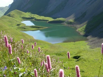
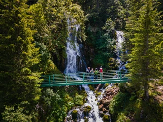
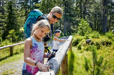
The highest peak in Lucerne – the Brienzer Rothorn – has moved its hikers since time immemorial. The Fototrail Rothorn creates even more moving moments. On the circular route, six photo stations offer unique motifs to create moving pictures. Physical activity is also guaranteed on the mountain hiking trail!
Opening hours
The Fototrail Rothorn is open daily during the summer season on the Brienzer Rothorn of Bergbahnen Sörenberg AG. More information can be found here.
Prices
The Fototrail is free of charge. You can reach the start and end point of the Fototrail comfortably with the Sörenberg - Brienzer Rothorn aerial cableway. For the way from Eisee back to Brienzer Rothorn, we recommend the Eisee chairlift; the pedestrian ticket can be purchased in the online shop or at the valley station of the aerial cableway.
Offers
The photo kit for CHF 19.50 contains the matching gadget for each photo station. Use these to achieve even more exciting, creative, and diverse photos. Additionally, you will find challenging photo challenges and instructive photography tips for each photo station in an accompanying small booklet. The photo kit can also be purchased in the online shop. You will receive the photo kit at the valley station with the order confirmation.
Equipment
All stations can basically be done with a current smartphone. However, a camera offers many more possibilities and allows you to switch from automatic to manual mode.
Also discover our winter Fototrail, where five staged photo stations await you on the winter hiking circular route Rossweid-Schwarzenegg in the magical winter wonderland!

Waypoints
Good to know
Pavements
Best to visit
Directions
Brienzer Rothorn mountain station – Brienzer Rothorn summit platform – Eisee saddle – Eisee mountain guesthouse – Eisee – Eisee chairlift connecting tunnel - Brienzer Rothorn
Tour information
Loop Road
Mountain Railway Tour
Stop at an Inn
Equipment
Good footwear, rain jacket & enough drinking water for the way are part of every hike.
More tips for safe hiking, information about suckler cow herds and protection dogs and much more can be found on the website of the Swiss Hiking Routes.
Directions & Parking facilities
The UNESCO Biosphere Entlebuch lies in the heart of Switzerland, centrally between Bern and Lucerne. You can reach Sörenberg via main road 10 towards Schüpfheim and from there to Flühli Sörenberg up to the valley station of the Sörenberg - Brienzer Rothorn aerial cableway.
In summer, you can reach Sörenberg via Sarnen - Giswil over the Glaubenbielen Pass.
A paid parking lot is available at the valley station of the aerial cableway.
You can reach Sörenberg by public transport via Schüpfheim (Bern-Lucerne train line). From Schüpfheim, you take the post bus to Sörenberg "Rothornbahn." Plan your trip with the SBB online timetable.
Additional information
Bergbahnen Sörenberg AG
Hinterschöniseistrasse 4
CH-6174 Sörenberg
Phone +41 (0)41 488 21 21
www.soerenberg.ch
Author
Bergbahnen Sörenberg AG
Organization
UNESCO Biosphäre Entlebuch
License (master data)
Bergbahnen Sörenberg AG

Author´s Tip / Recommendation of the author
Inspire and be inspired is the motto of the Fototrail Rothorn. Each photo station has its own hashtag with which you can share your photos. Share your top shots of the day with the #FototrailRothorn. When you search for these hashtags, you can see how other participants of the Fototrail have mastered the challenges.
Safety guidelines
The hiking trail Brienzer Rothorn - Eisee is a mountain hiking trail. Mountain hiking trails often follow uneven ground over roots and stones, are sometimes slippery, with high steps both uphill and downhill.
Nearby


Download GPX file