Moor Landscape Path Stage 5: Moor Landscape Glaubenberg


- 4:40 h
- 12.43 km
- 826 m
- 1,045 m
- 1,103 m
- 1,806 m
- 703 m
- Start: Flühli, alpine restaurant Stäldeli
- Destination: Sörenberg, PostBus stop Sörenberg, Post
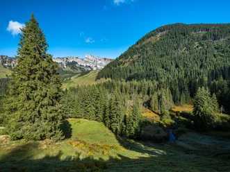
A hike with a marked ascent and descent through a primeval mountain pine raised bog on a long ridge with wide views of the Alps awaits you on this stage of the Moor Landscape Path.
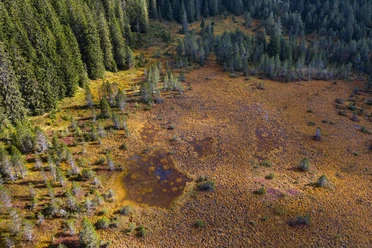
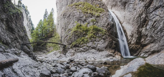
Special in the moor landscape is the Chessiloch with its impressive waterfall and suspension bridge. With the longest suspension bridge in Entlebuch, the hiking trail is ideally connected for a short detour. In Bleikebode, the species-rich fens are an eye-catcher as valued litter suppliers. And of course the Haglere (viewpoint) with the mountain pine raised bog forest, a 45-hectare nature reserve by Pro Natura. Here you walk through one of the largest and most beautiful raised bogs in the Entlebuch Biosphere. Take your time and observe the gnarled mountain pines. The dead trees provide food for many animal species. The path is soft, moist, and in many places the brown peat layer is exposed. Take off your shoes and socks here and walk barefoot for the next kilometer. A detour to the Haglere cross is highly recommended - the view is phenomenal, and also impressive is
the 700-meter long border wall.
After the detour to Haglere, you head downhill. Here you encounter the last moorland of this stage, the Mittlist-Gfäl fen. Besides the typical fen plants such as orchids and cotton grasses, wild chives also grow along the path here. Try a small piece of the violet flowering plant and compare the taste with that of garden chives. Caution: a similarly looking, protected orchid also blooms here. In early autumn, the moor is cut with a light mountain mower and scythe.
Via Alpweid, you hike into the village of Sörenberg, the destination of the last stage. Here you deserve a cool beer, fresh iced tea, or a fine dessert!
Moor Landscape Path UNESCO Biosphere Entlebuch
Discover here all stages of the five-day adventure through the Entlebuch moor landscapes.
Package Offer
While you hike on the marked Moor Landscape Path, enjoy the fascinating natural landscapes and tastefully enjoy the packed lunch at the most beautiful spots, your luggage travels to the next overnight location. Here too, you enjoy a great variety – from overnight stays in a tipi on the alp to a 3-star hotel with a regional 4-course menu – and fall into a deep, restful sleep. Here is the package offer.

Good to know
Best to visit
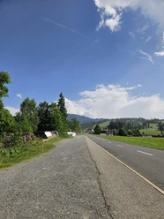
Directions
- Stäldili - Gitziloch - Bleikechopf - DäleBode - Alpweid - Sörenberg Post
- The route is marked with the sign "Moor Landscape Path" and can also be walked in the opposite direction.
- The stages "Habkern/Sörenberg" or "Glaubenberg (Stage 1)" can be linked to this route.
Variants
Ascent from Flühli to Gitziloch: 2h, 410m ascent
Descent from Gitziloch to Flühli: 1h30, 410m descent
Ascent & descent DäleBode-Haglere: 40 min, 140m ascent/descent
Tour information
Nature Highlight
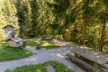
Stop at an Inn
Equipment
Good footwear and all-weather equipment are essential. Recommended are binoculars, plant and animal identification books, possibly also a towel to dry your feet after barefoot walking.
Directions & Parking facilities
The UNESCO Biosphere Entlebuch is located in the heart of Switzerland, centrally between Bern and Lucerne. By car, you can reach the various stages via main road 10.
Plan your route using the Google route planner.
There are various free and paid parking spaces at the start locations.
You can reach the various stages by public transport via the Bern-Lucerne train line.
Plan your trip with the SBB online timetable.
Additional information
UNESCO Biosphere Entlebuch
Chlosterbüel 28
CH-6170 Schüpfheim
Tel. +41 (0)41 485 42 50
[email protected]
www.biosphaere.ch
Would you like to explore the moor with an expert? The UNESCO Biosphere Entlebuch is happy to organize guided hikes or excursions. Please inquire at the Biosphere Centre: [email protected] or Tel. +41 (0)41 485 42 50.
Author
UNESCO Biosphäre Entlebuch
Organization
UNESCO Biosphäre Entlebuch
License (master data)
UNESCO Biosphäre Entlebuch

Author´s Tip / Recommendation of the author
On this route, two detours are worthwhile; to the impressive Chessiloch waterfall and to the panoramic summit cross Haglere.
Safety guidelines
Mobile reception is partially difficult to impossible.
Map
The "Moor Landscape Path" brochure with many interesting details about the individual stages is available at the Biosphere Centre or can be ordered directly here.
Nearby

